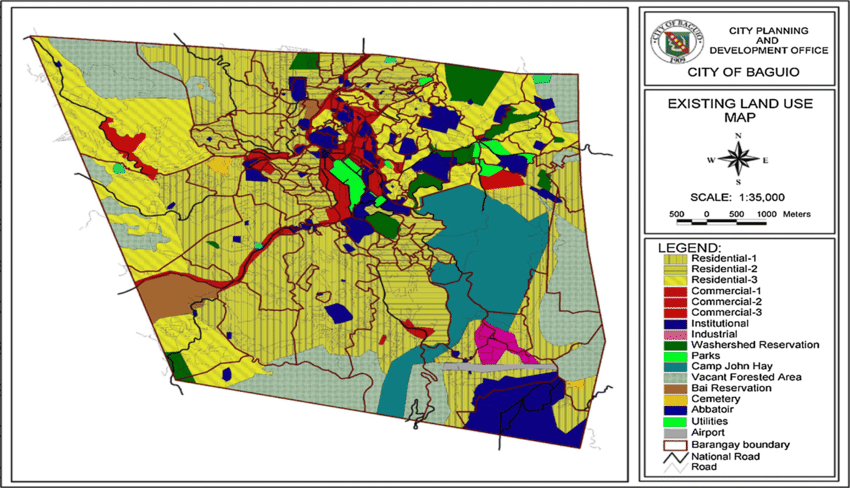
Land Use in Baguio City
Baguio City, with a total land area of approximately 57.5 square kilometers (5,750 hectares), is a highly urbanized city situated in the Cordillera mountains. Its land use is shaped by its mountainous terrain, cool climate, and role as the regional hub of Northern Luzon. The city government regulates land allocation through the Comprehensive Land Use Plan (CLUP), balancing urban development, environmental protection, and cultural preservation.
Major Land Use Categories
-
Residential Areas
-
Occupy a significant portion of Baguio’s land, often built on hillsides and slopes.
-
Housing ranges from traditional wooden and stone houses to modern subdivisions and boarding houses for students and workers.
-
-
Commercial Areas
-
Concentrated in Session Road, Burnham Park vicinity, Central Business District, Marcos Highway, and La Trinidad-Baguio corridor.
-
Includes malls, markets, restaurants, hotels, and small enterprises catering to tourism and local trade.
-
-
Institutional Areas
-
Home to major educational institutions like the University of the Philippines Baguio, Saint Louis University, University of Baguio, and University of the Cordilleras.
-
Also includes government offices (City Hall, regional offices), hospitals, and churches.
-
-
Industrial Areas
-
Small-scale industries and service-oriented businesses, mostly in designated zones such as the Baguio City Economic Zone (Loakan).
-
Focused on electronics, garments, handicrafts, and food processing.
-
-
Parks and Open Spaces
-
Baguio is known for its green zones like Burnham Park, Botanical Garden, Wright Park, and Mines View Park.
-
These serve as recreation areas, tourist attractions, and cultural landmarks.
-
-
Forest and Watershed Reservations
-
About 30% of Baguio’s land area is designated as forest and watershed zones, such as the Busol Watershed, Camp John Hay forest reservation, and Buyog watershed.
-
These are vital for water supply, biodiversity, and climate regulation, though many face challenges from urban encroachment and informal settlements.
-
-
Agricultural Areas
-
Limited due to the city’s topography and urban expansion.
-
Small plots for vegetable gardens and strawberry farming exist on the outskirts and adjacent municipalities.
-
Key Issues in Land Use
-
Urban congestion: High population density and in-migration strain land resources.
-
Environmental degradation: Encroachment on forest reserves and watersheds.
-
Traffic and zoning conflicts: Commercial growth overlapping with residential areas.
-
Tourism pressure: Increased demand for hotels, restaurants, and facilities affecting land allocation.